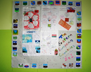
These are the final Projects that the F1 and F2 students of the 4th Pefki Primary School produced. The idea came forth based on the content of Unit 1 in our English School Book.
Read more
The main aims of this Project were to make students:
- develop a basic knowledge of the geography of the Eastern European Countries
- collect, organize and display information about a selected Eastern European Country in English
- use the vocabulary of geographical features and various nationalities in English
- collaborate
We spent 80 minutes approximately plus the extra time students needed to complete their list of information at home.
STEP 1
The students:
- checked the map and spotted the Eastern European Countries
- completed a list of the names of these countries and the corresponding nationalities
STEP 2
The students:
- were introduced with the Project idea and formed groups of 4-6
- were assigned a specific country through a grab bag process
- were shown the graphic organiser that they would have to complete
- noted down the categories of information that they would have to collect
- assigned these categories among them in each group
STEP 3
The students worked individually at home to collect information with the help of their F’ Class Geography Books and any other source available.(Unfortunately, there was a problem with the internet connection at the school computers room, so we weren’t able to use the internet at school.)
STEP 4
The students:
- brought the information back at a following date and completed their graph
- coloured the landforms pictures, wrote the greek translation and pasted them as a frame around the Project template, which was a piece of pinboard paper roll.
- made any improvements needed to the whole presentation
WELL DONE STUDENTS!
The landforms pictures used came from
http://www.superteacherworksheets.com/ Landforms – Cut & Glue Free
The graphic organiser used came from
eduplace.com/graphicorganizer/
Suggested sites for this project:
http://europa.eu/about-eu/countries/
http://www.nationsonline.org/oneworld/europe.htm
http://www.worldatlas.com/webimage/countrys/eu.htm


