The Yangtze or Yangzi is the longest river in Asia, the third-longest in the world, and the longest in the world to flow entirely within one country. It rises at Jari Hill in the Tanggula Mountains (Tibetan Plateau) and flows 6,300 km (3,900 mi) in a generally easterly direction to the East China Sea. It is the seventh-largest river by discharge volume in the world. Its drainage basin comprises one-fifth of the land area of China, and is home to nearly one-third of the country’s population.
The Yangtze has played a major role in the history, culture, and economy of China. For thousands of years, the river has been used for water, irrigation, sanitation, transportation, industry, boundary-marking, and war. The prosperous Yangtze Delta generates as much as 20% of China’s GDP. The Three Gorges Dam on the Yangtze is the largest hydro-electric power station in the world that is in use. In mid-2014, the Chinese government announced it was building a multi-tier transport network, comprising railways, roads and airports, to create a new economic belt alongside the river.
The Yangtze flows through a wide array of ecosystems and is habitat to several endemic and threatened species including the Chinese alligator, the narrow-ridged finless porpoise, and also was the home of the now extinct Yangtze river dolphin (or baiji) and Chinese paddlefish, as well as the Yangtze sturgeon, which is extinct in the wild. In recent years, the river has suffered from industrial pollution, plastic pollution, agricultural runoff, siltation, and loss of wetland and lakes, which exacerbates seasonal flooding. Some sections of the river are now protected as nature reserves. A stretch of the upstream Yangtze flowing through deep gorges in western Yunnan is part of the Three Parallel Rivers of Yunnan Protected Areas, a UNESCO World Heritage Site.
Etymology
Chinese
Cháng Jiāng (长江; 長江) is the official name for the Yangtze in Mandarin Chinese. However, the Chinese have given different names to the upstream sections of the river up to its confluence with the Min River at Yibin, Sichuan Jinsha River (“Gold Sands River”) refers to the 2,308 km (1,434 mi) of the Yangtze from Yibin upstream to the confluence with the Batang River near Yushu in Qinghai, while the Tongtian River (“River that leads to Heaven”) describes the 813 km (505 mi) section from Yushu up to the confluence of the Tuotuo River and the Dangqu River.
Chang Jiang literally means the “Long River.” In Old Chinese, the Yangtze was simply called Jiang/Kiang 江, a character of phono-semantic compound origin, combining the water radical 氵 with the homophone 工 (now pronounced gōng, but *kˤoŋ in Old Chinese). Krong was probably a word in the Austroasiatic language of local peoples such as the Yue. Similar to *krong in Proto-Vietnamese and krung in Mon, all meaning “river”, it is related to modern Vietnamese sông (river) and Khmer krung (city on riverside), whence Thai krung (กรุง capital city), not kôngkea (water) which is from the Sanskrit root gáṅgā
By the Han dynasty, Jiāng had come to mean any river in Chinese, and this river was distinguished as the “Great River” 大江 (Dàjiāng). The epithet 長 (simplified version 长), means “long”, was first formally applied to the river during the Six Dynasties period.
Various sections of the Yangtze have local names. From Yibin to Yichang, the river through Sichuan and Chongqing Municipality is also known as the Chuān Jiāng (川江) or “Sichuan River.” In Hubei, the river is also called the Jīng Jiāng (荆江; 荊江) or the “Jing River” after Jingzhou, one of the Nine Provinces of ancient China. In Anhui, the river takes on the local name Wǎn Jiāng after the shorthand name for Anhui, wǎn (皖). And Yángzǐ Jiāng (揚子江; 扬子江) or the “Yangzi River”, from which the English name Yangtze is derived, is the local name for the Lower Yangtze in the region of Yangzhou. The name likely comes from an ancient ferry crossing called Yángzǐ or Yángzǐjīn (揚子 / 揚子津)Europeans who arrived in the Yangtze River Delta region applied this local name to the whole river The dividing site between upstream and midstream is considered to be at Yichang and that between midstream and downstream at Hukou (Jiujiang)
Geography

The river originates from several tributaries in the eastern part of the Tibetan Plateau, two of which are commonly referred to as the “source.” Traditionally, the Chinese government has recognized the source as the Tuotuo tributary at the base of a glacier lying on the west of Geladandong Mountain in the Tanggula Mountains. This source is found at 33°25′44″N 91°10′57″E and while not the furthest source of the Yangtze, it is the highest source at 5,342 m (17,526 ft) above sea level. The true source of the Yangtze, hydrologically the longest river distance from the sea, is at Jari Hill at the head of the Dam Qu tributary, approximately 325 km (202 mi) southeast of Geladandong.This source was only discovered in the late 20th century and lies in wetlands at 32°36′14″N 94°30′44″E and 5,170 m (16,960 ft) above sea level just southeast of Chadan Township in Zadoi County, Yushu Prefecture, Qingha As the historical spiritual source of the Yangtze, the Geladandong source is still commonly referred to as the source of the Yangtze since the discovery of the Jari Hill source.
These tributaries join and the river then runs eastward through Qinghai (Tsinghai), turning southward down a deep valley at the border of Sichuan (Szechwan) and Tibet to reach Yunnan. In the course of this valley, the river’s elevation drops from above 5,000 m (16,000 ft) to less than 1,000 m (3,300 ft).
It enters the basin of Sichuan at Yibin. While in the Sichuan basin, it receives several mighty tributaries, increasing its water volume significantly. It then cuts through Mount Wushan bordering Chongqing and Hubei to create the famous Three Gorges. Eastward of the Three Gorges, Yichang is the first city on the Yangtze Plain.
After entering Hubei province, the Yangtze receives water from a number of lakes. The largest of these lakes is Dongting Lake, which is located on the border of Hunan and Hubei provinces, and is the outlet for most of the rivers in Hunan. At Wuhan, it receives its biggest tributary, the Han River, bringing water from its northern basin as far as Shaanxi.
At the northern tip of Jiangxi province, Lake Poyang, the biggest freshwater lake in China, merges into the river. The river then runs through Anhui and Jiangsu, receiving more water from innumerable smaller lakes and rivers, and finally reaches the East China Sea at Shanghai.
Four of China’s five main freshwater lakes contribute their waters to the Yangtze River. Traditionally, the upstream part of the Yangtze River refers to the section from Yibin to Yichang; the middle part refers to the section from Yichang to Hukou County, where Lake Poyang meets the river; the downstream part is from Hukou to Shanghai.
The origin of the Yangtze River has been dated by some geologists to about 45 million years ago in the Eocene but this dating has been disputed.
Image gallery
-

The glaciers of the Tanggula Mountains, the traditional source of the Yangtze River
-

The Tuotuo River, a headwater stream of the Yangtze River, known in Tibetan as Maqu, or the “Red River”
-
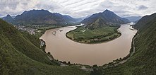
The first turn of the Yangtze at Shigu (石鼓) in Yunnan, where the river turns 180 degrees from south- to north-bound
-

Narrowest point of the Tiger Leaping Gorge near Lijiang downstream from Shigu
-

The Jinsha, “Golden Sands River”, in Yunnan
-
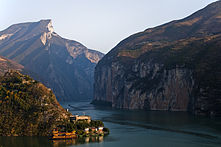
Qutang Gorge, one of the Three Gorges
-
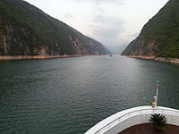
Wu Gorge, one of the Three Gorges
-

Xiling Gorge, one of the Three Gorges
Wildlife
The Yangtze River has a high species richness, including many endemics. A high percentage of these are seriously threatened by human activities.
Fish
 The two sturgeon species in the Yangtze (here Chinese sturgeon) are both seriously threatened.
As of 2011, 416 fish species are known from the Yangtze basin, including 362 that strictly are freshwater species. The remaining are also known from salt or brackish waters, such as the river’s estuary or the East China Sea. This makes it one of the most species-rich rivers in Asia and by far the most species-rich in China (in comparison, the Pearl River has almost 300 fish species and the Yellow River 160). 178 fish species are endemic to the Yangtze River Basin Many are only found in some section of the river basin and especially the upper reach (above Yichang, but below the headwaters in the Qinghai-Tibet Plateau) is rich with 279 species, including 147 Yangtze endemics and 97 strict endemics (found only in this part of the basin). In contrast, the headwaters, where the average altitude is above 4,500 m (14,800 ft), are only home to 14 highly specialized species, but 8 of these are endemic to the river.The largest orders in the Yangtze are Cypriniformes (280 species, including 150 endemics), Siluriformes (40 species, including 20 endemics), Perciformes (50 species, including 4 endemics), Tetraodontiformes (12 species, including 1 endemic) and Osmeriformes (8 species, including 1 endemic). No other order has more than four species in the river and one endemic.
Many Yangtze fish species have declined drastically and 65 were recognized as threatened in the 2009 Chinese red list Among these are three that are considered entirely extinct (Chinese paddlefish, Anabarilius liui liui and Atrilinea macrolepis), two that are extinct in the wild (Anabarilius polylepis, Schizothorax parvus), four that are critically endangered Euchiloglanis kishinouyei, Megalobrama elongata, Schizothorax longibarbus and Leiocassis longibarbus) Additionally, both the Yangtze sturgeon and Chinese sturgeon are considered critically endangered by the IUCN. The survival of these two sturgeon may rely on the continued release of captive bred specimens. Although still listed as critically endangered rather than extinct by both the Chinese red list and IUCN, recent reviews have found that the Chinese paddlefish is extinct. Surveys conducted between 2006 and 2008 by ichthyologists failed to catch any, but two probable specimens were recorded with hydroacoustic signals. The last definite record was an individual that was accidentally captured near Yibin in 2003 and released after having been radio tagged. The Chinese sturgeon is the largest fish in the river and among the largest freshwater fish in the world, reaching a length of 5 m (16 ft); the extinct Chinese paddlefish reputedly reached as much as 7 m (23 ft), but its maximum size is labeled with considerable uncertainty.
 The silver carp is native to the river, but has (like other Asian carp) been spread through large parts of the world with aquaculture.
The largest threats to the Yangtze native fish are overfishing and habitat loss (such as building of dams and land reclamation), but pollution, destructive fishing practices (such as fishing with dynamite or poison) and introduced species also cause problems. About 2⁄3 of the total freshwater fisheries in China are in the Yangtze Basin, but a drastic decline in size of several important species has been recorded, as highlighted by data from lakes in the river basin In 2015, some experts recommend a 10-year fishing moratorium to allow the remaining populations to recover and in January 2020 China imposed a 10-year fishing moratorium on 332 sites along the Yangtze. Dams present another serious problem, as several species in the river perform breeding migrations and most of these are non-jumpers, meaning that normal fish ladders designed for salmon are ineffective. For example, the Gezhouba Dam blocked the migration of the paddlerfish and two sturgeon, while also effectively splitting the Chinese high fin banded shark population into two and causing the extirpation of the Yangtze population of the Japanese eel. In an attempt of minimizing the effect of the dams, the Three Gorges Dam has released water to mimic the (pre-dam) natural flooding and trigger the breeding of carp species downstream. In addition to dams already built in the Yangtze basin, several large dams are planned and these may present further problems for the native fauna.
While many fish species native to the Yangtze are seriously threatened, others have become important in fish farming and introduced widely outside their native range. A total of 26 native fish species of the Yangtze basin are farmed. Among the most important are four Asian carp: grass carp, black carp, silver carp and bighead carp. Other species that support important fisheries include northern snakehead, Chinese perch, Takifugu pufferfish (mainly in the lowermost sections) and predatory carp.
Other animals
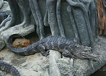 The critically endangered Chinese alligator is one of the smallest crocodilians, reaching a maximum length of about 2 m (7 ft).
Due to commercial use of the river, tourism, and pollution, the Yangtze is home to several seriously threatened species of large animals (in addition to fish): the narrow-ridged finless porpoise, baiji (Yangtze river dolphin), Chinese alligator, Yangtze giant softshell turtle and Chinese giant salamander. This is the only other place besides the United States that is native to an alligator and paddlefish species. In 2010, the Yangtze population of finless porpoise was 1000 individuals. In December 2006, the Yangtze river dolphin was declared functionally extinct after an extensive search of the river revealed no signs of the dolphin’s inhabitance. In 2007, a large, white animal was sighted and photographed in the lower Yangtze and was tentatively presumed to be a baiji. However, as there have been no confirmed sightings since 2004, the baiji is presumed to be functionally extinct at this time. “Baijis were the last surviving species of a large lineage dating back seventy million years and one of only six species of freshwater dolphins.” It has been argued that the extinction of the Yangtze river dolphin was a result of the completion of the Three Gorges Dam, a project that has affected many species of animals and plant life found only in the gorges area.
Numerous species of land mammals are found in the Yangtze valley, but most of these are not directly associated with the river. Three exceptions are the semi-aquatic Eurasian otter, water deer and Père David’s deer.
 The entirely aquatic Chinese giant salamander is the world’s largest amphibian, reaching up to 1.8 m (5.9 ft) in length.
In addition to the very large and exceptionally rare Yangtze giant softshell turtle, several smaller turtle species are found in the Yangtze basin, its delta and valleys. These include the Chinese box turtle, yellow-headed box turtle, Pan’s box turtle, Yunnan box turtle, yellow pond turtle, Chinese pond turtle, Chinese stripe-necked turtle and Chinese softshell turtle, which all are considered threatened.
More than 160 amphibian species are known from the Yangtze basin, including the world’s largest, the critically endangered Chinese giant salamander. It has declined drastically due to hunting (it is considered a delicacy), habitat loss and pollution. The polluted Dian Lake, which is part of the upper Yangtze watershed (via Pudu River), is home to several highly threatened fish, but was also home to the Yunnan lake newt. This newt has not been seen since 1979 and is considered extinct. In contrast, the Chinese fire belly newt from the lower Yangtze basin is one of the few Chinese salamander species to remain common and it is considered least concern by the IUCN.
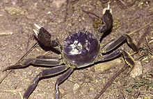 The Chinese mitten crab is a commercially important species in the Yangtze, but invasive in other parts of the world.
The Yangtze basin contains a large number of freshwater crab species, including several endemics. A particularly rich genus in the river basin is the potamid Sinopotamon. The Chinese mitten crab is catadromous (migrates between fresh and saltwater) and it has been recorded up to 1,400 km (870 mi) up the Yangtze, which is the largest river in its native range. It is a commercially important species in its native range where it is farmed, but the Chinese mitten crab has also been spread to Europe and North America where considered invasive.
The freshwater jellyfish Craspedacusta sowerbii, now an invasive species in large parts of the world, originates from the Yangtze.
https://www.tiktok.com/@hellofrombeijing/video/7173222503995821318


